- -€20.00


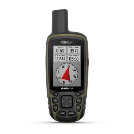
Garmin eTrex 32x is a robust and reliable portable GPS receiver with integrated compass and altimeter

Garmin eTrex 32x is a robust and reliable portable GPS receiver with integrated compass and altimeter
eTrex 22x and eTrex 32x offer the same intuitiveness, strength and convenience that eTrex portable GPS devices are known for but with the addition of preloaded TopoActive Europe maps. They are ideal for quad, bike, boat and excursion activities.
The eTrex 22x and 32x models are equipped with a 2.2 "65K color anti-glare screen. Resistant and waterproof, these devices are designed to withstand extreme weather conditions.
The eTrex 22x and 32x portable devices are preloaded with TopoActive Europe maps which include straight-ahead roads and paths. In this way you can discover the surrounding environment, such as waterways, paths surrounded by nature, as well as buildings, international borders and much more. In addition, you can find thousands of points of interest, including shops, restaurants, universities, car parks and accommodation.
The eTrex series uses the GPS and GLONASS satellite systems, therefore the integrated receiver is able to carry out surveys in the most remote places compared to GPS only. The eTrex 32x model adds a 3-axis compass and a barometric altimeter to facilitate heading maintenance.
Thanks to the microSD card slot and the expanded 8 GB internal memory, you can easily download additional maps for any adventure.
Both devices support BirdsEye satellite imagery (a subscription is required) to download and integrate satellite imagery with maps.
eTrex 22x and eTrex 32x support electronic geocaching. Upload GPX files directly to your device and view important information, such as location, terrain and Geocaching.com tips.
Thanks to a wide range of compatible supports, eTrex is designed to be an ideal portable GPS device for outdoor use, to be installed on quads, bikes or boats, but also for hiking. Use the automatic installation feature and City Navigator® NT maps for detailed driving directions, or the sturdy motorcycle or quad stand. Whatever the destination chosen, eTrex is equipped with maps and supports to reach it.
General |
|
| DIMENSIONS | 5.4 x 10.3 x 3.3 cm |
|---|---|
| SCREEN DIMENSIONS, LXA | 3.5 x 4.4 cm; 2.2 "diagonal (5.6 cm) |
| SCREEN RESOLUTION, LXA | 240 x 320 pixels |
| SCREEN TYPE | Transflective TFT from 2.2 "to 65K color |
| WEIGHT | 141.7 g (with batteries) |
| BATTERY | 2 AA batteries (not included); NiMH or lithium recommended |
| BATTERY LIFE | 25 hours |
| WATERPROOFING CLASSIFICATION | IPX7 |
| HIGH SENSITIVITY GPS RECEIVER | Yes |
| INTERFACE | mini USB |
| MEMORY / HISTORY | sheet |
Maps and memory |
|
| PRELOADED CARTOGRAPHY | Yes (TopoActive Europe; viable roads) |
|---|---|
| ADDITIONAL CARTOGRAPHY | Yes |
| WORLD BASEMAP | Yes |
| AUTOMATIC CALCULATION OF THE ROUTE (WITH PRECISE INDICATIONS OF THE TURNS) | Yes |
| MAP SEGMENTS | 3000 |
| BIRDSEYE | 250 BirdsEye Imagery files |
| INCLUDES DETAILED HYDROGRAPHIC INFORMATION (COASTAL LINES, RIVERS / LAKES, BOGS AND PERENNIAL AND SEASONAL WATER COURSES) | Yes |
| INCLUDES SEARCHABLE POINTS OF INTEREST (PARKS, CAMPEGGI, PANORAMIC POINTS AND PICNIC AREAS) | Yes |
| ALLOWS TO DISPLAY NATIONAL, STATE AND LOCAL PARKS, FORESTS AND NATURAL RESERVES | Yes |
| STORAGE AND POWER CAPACITY | 8 GB microSD ™ (not included) |
| STORABLE POSITIONS | 2000 |
| TRACES | 200 |
| TRACK LOG | 10,000 points, 200 saved tracks |
| STORABLE PATHS | 200 |
Sensors |
|
| GPS | Yes |
|---|---|
| GLONASS | Yes |
| BAROMETRIC ALTIMETER | Yes |
| COMPASS | Yes (with tilt compensation, 3 axes) |
| GPS COMPASS (ON THE MOVE) | Yes |
Daily smart functions |
|
| VIRB ™ REMOTE CONTROL | Yes |
|---|---|
Functions for outdoor activities |
|
| POINT TO POINT NAVIGATION | Yes |
|---|---|
| COMPATIBLE WITH BASECAMP ™ | Yes |
| AREA CALCULATION | Yes |
| CALENDAR FOR HUNTING AND FISHING | Yes |
| EPHEMERIDES | Yes |
| SUITABLE FOR GEOCACHING | Yes (computerized) |
| COMPATIBLE WITH CUSTOMIZED MAPS | yes (100 custom map tiles) |
| IMAGE VIEWER | |
Connections |
|
| WIRELESS CONNECTIVITY |
yes (ANT + ®) |
|---|---|
Additional features |
|
| ADDITIONAL FEATURES | Wireless connectivity: ANT + |
|---|---|