- -€30.00


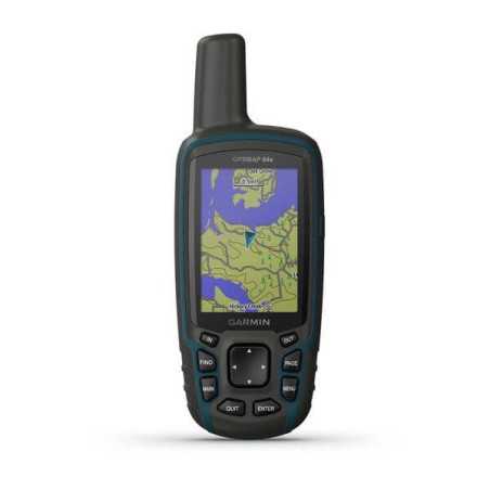
Satellite Navigator designed for outdoor activities. The Garmin GpsMap 64SX is your indispensable companion for a thousand adventures. Hiking, climbing, mushrooming, geocaching, kayaking or mountain biking - explore any place thanks to the orientation functions.

Satellite Navigator designed for outdoor activities. The Garmin GpsMap 64SX is your indispensable companion for a thousand adventures. Hiking, climbing, mushrooming, geocaching, kayaking or mountain biking - explore any place thanks to the orientation functions.
Satellite Navigator designed for outdoor activities.
The Garmin GpsMap 64SX is your indispensable companion for a thousand adventures.
Hiking, climbing, mushrooming, geocaching, kayaking or mountain biking - explore any place thanks to the orientation functions.
|
General |
|
|
DIMENSIONS |
6.1 x 16.0 x 3.6 cm |
|
SCREEN SIZE, WXH |
3.6 x 5.5 cm; 2.6 "diagonal |
|
SCREEN RESOLUTION, LXH |
160 x 240 pixels |
|
TYPE OF SCREEN |
Transflective TFT color touchscreen |
|
WEIGHT |
217 g with batteries |
|
BATTERY |
2 AA batteries (not included); NiMH or lithium recommended |
|
BATTERY LIFE |
Up to 16 hours |
|
WATERPROOF CLASSIFICATION |
IPX7 |
|
MIL-STD-810 |
yes (temperature, shocks, water) |
|
HIGH SENSITIVITY GPS RECEIVER |
YES |
|
INTERFACE |
high speed micro USB and NMEA 0183 compatible |
|
MEMORY / HISTORY |
8 GB |
|
Maps and memory |
|
|
ADDITIONAL CARTOGRAPHY |
YES |
|
WORLD BASEMAP |
Yes |
|
AUTOMATIC ROUTE CALCULATION (WITH PRECISE INDICATIONS OF TURNS) |
Yup |
|
MAP SEGMENTS |
3000 |
|
BIRDSEYE |
250 |
|
INCLUDES DETAILED HYDROGRAPHIC INFORMATION (COAST LINES, BANKS OF RIVERS / LAKES, MARSHES AND PERENNIAL AND SEASONAL WATER COURSES) |
YES |
|
INCLUDES SEARCHABLE POINTS OF INTEREST (PARKS, CAMPEGGI, PANORAMIC POINTS AND PICNIC AREAS) |
Yes |
|
ALLOWS TO VIEW NATIONAL, STATE AND LOCAL PARKS, FORESTS AND NATURAL RESERVES |
YES |
|
STORAGE AND FEEDING CAPACITY |
MicroSD ™ card (not included) |
|
POSITIONS THAT CAN BE STORED |
5,000 |
|
TRACES |
200 |
|
TRACK LOG |
10,000 points, 200 gpx tracks |
|
ROUTES CAN BE STORED |
200 |
|
Sensors |
|
|
GPS |
YES |
|
GLONASS |
YES |
|
GALILEO |
YES |
|
BAROMETRIC ALTIMETER |
YES |
|
COMPASS |
Yes (with tilt compensation, 3 axis) |
|
GPS COMPASS (IN MOTION) |
YES |